Mildura Police is warning motorists not to rely on Apple I-phones running iOS 6 when using the mapping system. A number of motorists have been directed off course in recent weeks.
Local police have been called in to help motorists who are stranded after following directions from their Apple iPhone within the Murray-Sunset National Park. This report has been all over the national and Australian News.
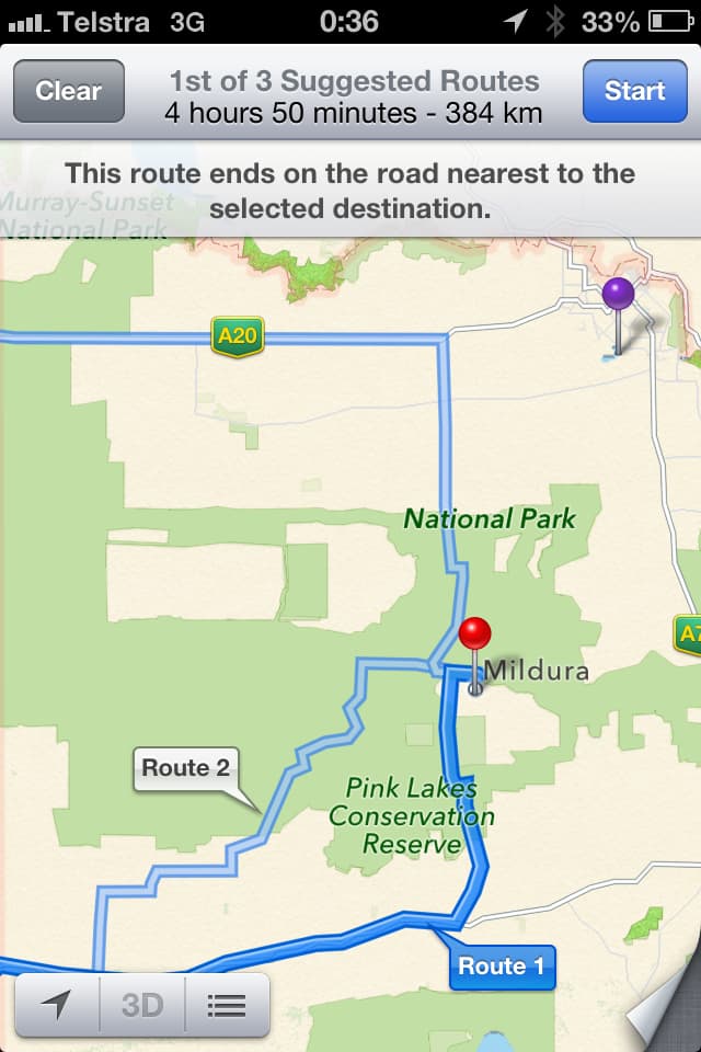
Police tests on the mapping system confirm that the mapping systems lists Mildura as being in the middle the Murray Sunset National Park – approximately 70km from the actual location.
The police are very concerned because there is no supply of water within the Park, and temperatures can rise to 46 degrees. This could be a life-threatening situation.
Police have found motorists who have been stranded without food and water for up to 24 hour. They have also walked through dangerous terrain in order to reach a phone signal.
Apple has been contacted by the police in relation to this issue. They hope that the issue is resolved quickly to ensure the safety and security of motorists traveling to Mildura.
Travelers to Mildura and other places in Victoria should use other maps until the issue is resolved.
Apple’s iOS 6 mobile OS has a major new feature: a mapping module that was developed by the company itself. This replaces the Google maps that were standard on iPhones since 2007. Apple’s decision to cut ties with Google is not a result of customer demand but corporate politics. Google’s Android is the greatest threat to the iPhone. Apple may not have liked Google Maps as much as iPhone users, but Apple does not like Google.
Apple’s maps are a problem.
Apple’s iOS 6 mobile OS has a major new feature: a mapping module that was developed by the company itself. This replaces the Google maps that were standard on iPhones since 2007. Apple’s decision to cut ties with Google is not based on user demands, but corporate politics. Google’s Android is the greatest threat to the iPhone. Apple may not have liked Google Maps as much as iPhone users, but Apple does not like Google.
It’s going be messy for them.
Apple’s maps are not up to par with Google’s. Users immediately complained about Apple’s new maps after the release of iOS 6 yesterday. The maps lack detail and do not include public transportation directions. Apple’s decision not to use Google Maps, despite the fact that it is an essential feature of modern smartphones, is an example of a company putting its own interests ahead of those of their customers. Rene Ritchie is the editor of More. They’ll get hammered from mom and pop looking for a store. “It’s going be messy for them.”
Problems are worse outside the US. London, Beijing and Tokyo have virtually no map detail, while some American cities may be missing it. Several major landmarks in these cities are incorrectly labeled or misplaced. In the US, satellite views are comparable to Google’s; however, internationally they could be obscured by cloud cover. Verge Senior Editor Tom Warren says that “it’s national news” for the UK. Politicians are using the controversy to boost their own egos. Ireland Justice Minister Alan Shatter released a statement stating that he was worried about a 35-acre farm and garden called Airfield located in his district being mislabeled as an airport icon. Shatter said that the designation was not only incorrect but dangerously misleading. “I’ve arranged for Apple to be informed of this error and asked that it be corrected urgently.”
What is the Statue of Liberty all about? Gone. Brooklyn Bridge gone? Obliterated.
Apple’s much-touted 3D flyover feature is a bit broken. It displays comically distorted pictures that make it look as if major landmarks and buildings have been destroyed. The Statue of Liberty is gone? Gone. The Brooklyn Bridge? Obliterated. Twitter users began collecting examples with the hashtag #ios6apocalypse. A Tumblr named The Amazing iOS 6 Maps soon filled up. Ritchie says that Apple’s 3D map makes for a “great commercial.” “But they are nowhere near as helpful as Google Street View.”
Apple’s maps have a disadvantage when it comes to users. Google maps is the industry standard and users know their quirks and limits after years of usage. Apple’s and Google’s maps have the same issues when compared head-to-head: searching for Lexington Avenue in Manhattan in Apple Maps brings up a Brooklyn Street, while Google found an initial result in New Jersey. Both maps will work well if you are looking for a particular restaurant or store, especially if the city is entered. They also do well based on general search terms such as “Italian Restaurant” in an area with a lot of people. Even if results differ, when a search is wrong, the error will often be equally bad on both maps. Apple also doesn’t do itself any favors: A search for “Apple Cube”, fails to locate Apple’s Fifth Avenue store, which is located in New York.
It takes time and effort to learn how to do it right.
Why are there so many bad data and broken functions? It’s difficult to build maps. There are only a few mapping data providers around the world and they have all been collecting information for years. Sources told us Apple started working on its iOS 6 maps system five years ago, not coincidentally at the same time that Google released Android. To get to this point, the company had to purchase smaller mapping companies and combine maps from multiple vendors. Apple uses TomTom in the US but other services overseas. The maps are patchy and have obvious rough edges compared to Google. Google has been improving its maps for many years. Not only have they been driving their quirky StreetView cars around the globe, but it has also been collecting location information from millions of iPhone users and Android users in order to improve its accuracy. Apple is just getting started.
The New York Times quoted Google maps’ VP Brandon McClendon as saying, “It will take a lot of time and effort for you to get it right.” Experience is key. Apple is not the only company of Apple’s scale that doesn’t try: Amazon signed a contract to use Nokia Maps on its Kindle Fire device.
Apple’s approach to mapping can be seen when browsing the map. Instead of showing locations directly on the maps like Google, Apple uses Yelp data to overlay restaurants, gas stations or bus stops. It’s often a good thing: You can tap on them to view Yelp ratings, or go to the detailed address page. Yelp’s results are crowd-sourced and can appear random. Apple icons and Google annotations are similar in New York or DC. However, Apple only places a few icons when there are many more that can be found by searching. This undermines its promise of providing a better browsing environment. Yelp is a popular tool in the US but it doesn’t appear to be replaced in other countries.
Losing mass transit routes is a big blow
Apple didn’t even have the time to catch up with other Google features. Losing mass transit directions was a huge blow. Manik Gupta, Senior Product Manager at Google Maps, told us that Transit was “integral to Maps very quickly after its launch.” It’s an extremely common use case. If you live in a big city, especially one with a good Metro system, like those found in Europe and Asia… take a look at Tokyo. “The whole city runs on public transit.” When searching for directions in iOS 6, selecting the familiar bus icon brings up a list local transit apps, either available from the App Store or installed on your phone. Apple will feed the app with information if it is already installed. This should minimize the amount of extra work. Transit apps have improved over the years but they can’t match the seamless integration of buses, trains, commuter rails, and foot traffic offered by Google at its best. Transit apps are usually localized to a particular city, so you might have to install several tools that use different interfaces when you travel.
Apple’s maps have some advantages, especially in large American cities where Apple’s software is roughly on par with Google’s. Apple Maps don’t include annoying features such as sponsored listings or ads. The company also offers turn-by-turn directions for free, which Google has offered for years on Android phones. These benefits are only apparent when viewed in conjunction with a solid core mapping experience. Most users seem to be happy to accept some ads for reliable, accurate data.
Apple is in a difficult position, as it is about to launch a media frenzy when the iPhone 5 is released tomorrow. iOS 6 is a much more modest release than previous versions. It has fewer features, compared to the past. There are no major new features like Siri, multitasking, or AirPlay. “Maps are a major undertaking,” says , iMore. It took a lot more time than they could have spent on user-facing features.
Apple wanted Google off the phone.
Apple will have little else to rely on when it starts to promote the new iPhone. Ross Rubin is the principal analyst at Reticle Research and he says that maps are definitely the highlight of iOS 6. We can expect Apple’s iPhone ads to feature the new maps. Google has a unique opportunity as well: it was widely expected that the company would release its own map app for iOS in conjunction with the iPhone 5. However, the company has not said or done anything other than reminding people Google maps is still available on Android and being updated.
Apple ultimately created this problem. Ritchie’s bluntness is evident when he notes that critics have said Apple’s iPhone 5 and OS are iterative upgrades to previous products. He says that “iOS6 is mainly about Apple – they wanted Google off their phones.” Google Maps, YouTube and other popular apps are no longer available on the iPhone’s default homescreen . It’s a question of whether Apple’s victories are also victories for their customers.